
Looking into Togwotee Pass backcountry skiing or snowboarding? located in the Bridger-Teton National Forest in Wyoming, the area surrounding the pass contains some great cross-country skiing and it is well known for its snowmobile terrain. And It just so happens that Togwotee Pass also hosts some epic backcountry. Oh, and keep in mind that there is a run at Jackson Hole called Togwotee Pass, but that’s not what we’re talking about here.
This zone tends to get overlooked with its proximity to Grand Tetons and Yellowstone National Parks as well as Jackson Hole, but it has served as a backcountry destination for generations. As backcountry interest surged with pandemic-related restrictions, this zone has picked up a little extra traffic in recent seasons. It should stay on your radar for this Western Wyoming region, particularly due to its extended season. You can often find workable Togwotee Pass backcountry sking both earlier and later in the season than other destinations in the vicinity.
Two of the best resources I was able to find when digging into this region are an old article by Dan Kostrzewski covering the key zones and a short and funky blog post mentioning some specific routes. Information for this region can be a little sparse in comparison to it’s nearby cousins.
Just little history for you before we get started, because it’s always good to add a little relevant understanding to your backcountry expeditions. The pass is named for a sub-chief of a band of Shoshone known as the Tukudeka. In 1873, Chief Togwotee is credited as having lead The Jones Expedition over this pass, a recognized tribal trade route at the time.
Togwotee Pass Avalanche Risk
This is known avalanche territory. You can find current avalanche forecasting reports for the Togwotee Pass region here. As always, travel with all of your avalanche gear at all times. AIARE 1 training is more than recommended for the region.
It doesn’t much help matters that Togwotee Pass is something of a magnet for motorized recreation. In addition to pre-existing avalanche danger, the risk of a third-party avalanche trigger is real. Not to stoke ire between the motored and motorless; certainly, some of the best ski terrain in the region is best accessed via snowmobile. Just a factor to be aware of.
The most recent noted avalanche-related fatality in the region occurred in February of 2021, not far from the parking lot at the peak of Togwotee Pass. A snowboarder was deeply submerged in a creek bed after triggering a slab avalanche at the landing of a newly constructed jump. The snowboarders companions were familiar with avalanche rescue and quickly located their companion, but he was too deeply submerged
You should receive proper avalanche training before entering the Togwotee Pass backcountry. Carry your beacons, shovels and probes.
Directions to Togwotee Pass Backcountry Skiing
Follow Highway 26 East for about 30 minutes out of Moran, WY and you encounter Togwotee Pass. This high-mountain pass peaks at just over 9,600 ft as it runs between the 10,724′ Two Ocean Mountain and 11,007′ Breccia Peak.
There are well-regarded routes peppered along Highway 26, mostly between Togwotee Mountain Lodge and Wind River Lake Picnic Site. There are a number of parking areas on the 10 mile stretch between those two points.
Togwotee Pass Backcountry Ski Routes
There’s plenty of terrain in the region. One of the best approaches here, especially if you’re unfamiliar with the region, is to find one of the lower, more avalanche-protected spots and run quick laps. You can hit a bunch of fun lines this way while minimizing risk.
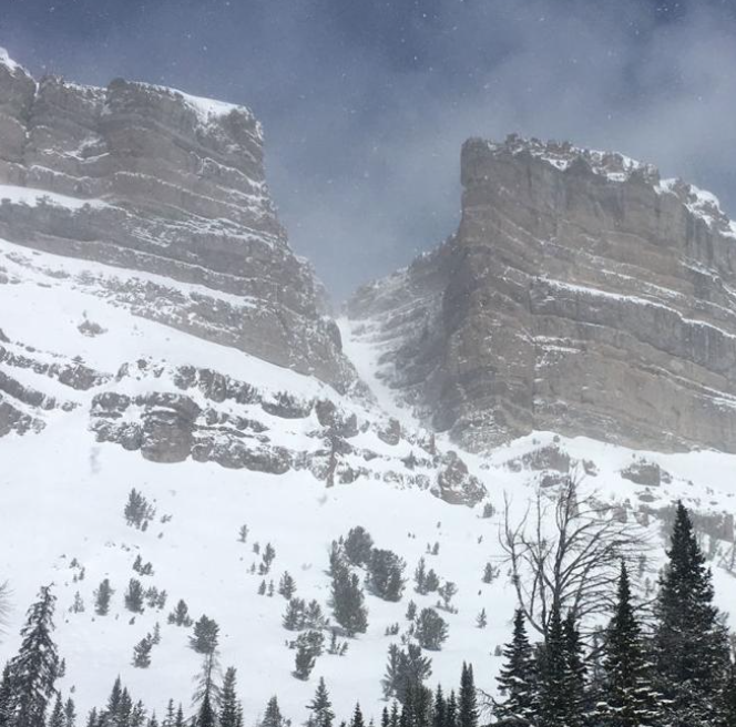
Breccia Peak
Perhaps the most accessible route is Breccia Peak. Park on the north side of 26 in the pull-out just below The Continental Divide. There should be skin tracks around to show you the way, or a way at least. Skin up through the trees and follow the drainage towards the meadows.
You can summit Breccia peak at a mellow enough climb that puts you up around 1,000 feet of elevation over 2 miles. You’ll peak out at around a 40% grade.
From the top, you can can come down the way you came. Or for a challenge, drop down the back side on the North Woods line or any of the other various lines to be had at your own peril. Just follow the ridge to the first stand of trees you encounter.
East Angle
Just North West of USFS road 30035 you should come to a parking area on the side of the Angle Mountain side of the road. From this parking area, start your skin, continuing parallel to the highway back towards Moran until the trail turns and follows the ridge line up to the peak of Angle Mountain.
Mostly some nice, intermediate terrain. These are some short lines, easily accessed from the highway. At around the half way point of your ascent, there’s a fork available to the South East if you want to do some quicker and steeper laps. This route peaks at around a 60% grade, so it can get a little aggressive.
Two Ocean Mountain Backcountry Skiing
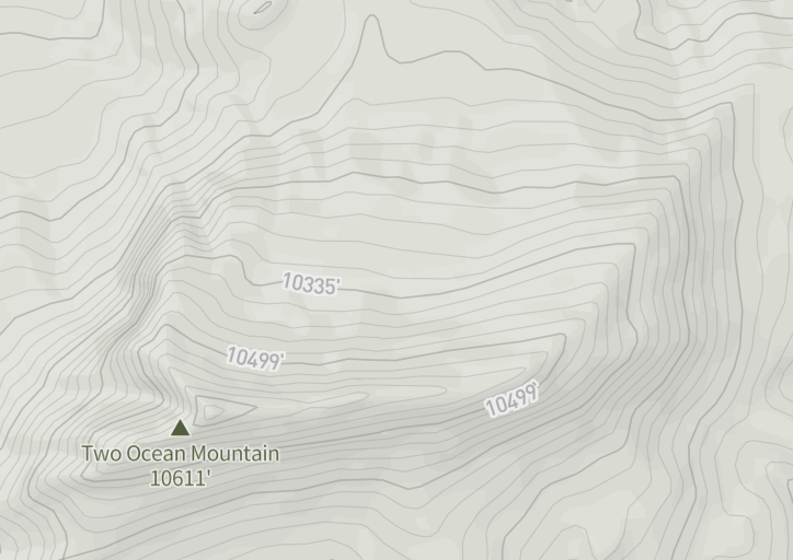
This one is maybe best serviced with a snowmobile, not as much for the distance as for the other snowmobile traffic, a contentious topic with the locals.
The peak is visible from the highway and a dirt road that heads out in the direction of the mountain is sometimes accessible and can get you pretty close to its base.
If you’re headed up from the Teton side, just past the after the pass, you can park at the turnout on the right. Then head across the meadow. Boot or skin up the ridge and you’ve got a ton of options. Again, you just may be competing with those snowmobiles.
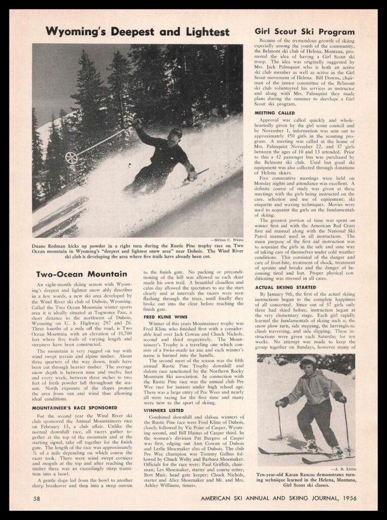
At one point, there was a rope tow operating on Two Ocean. I’ve found references suggesting that the original tow rope was installed as early as the 1930’s, and the mountain is often described as one of Wyoming’s first ski areas. But the earliest print reference I could find is this article from the 1956 issue of American Skiing Annual and Ski Journal which points to it as ‘a new ski area’, referring to the mountain as, ‘the Two Ocean Mountain winter sports area’.
You might just be able to still find some old timers who know Two Ocean from wayyyy back. The snowmobile traffic picked up in the nineties and local skiers now tend to avoid the region in peak months. Still, it looks pretty workable.
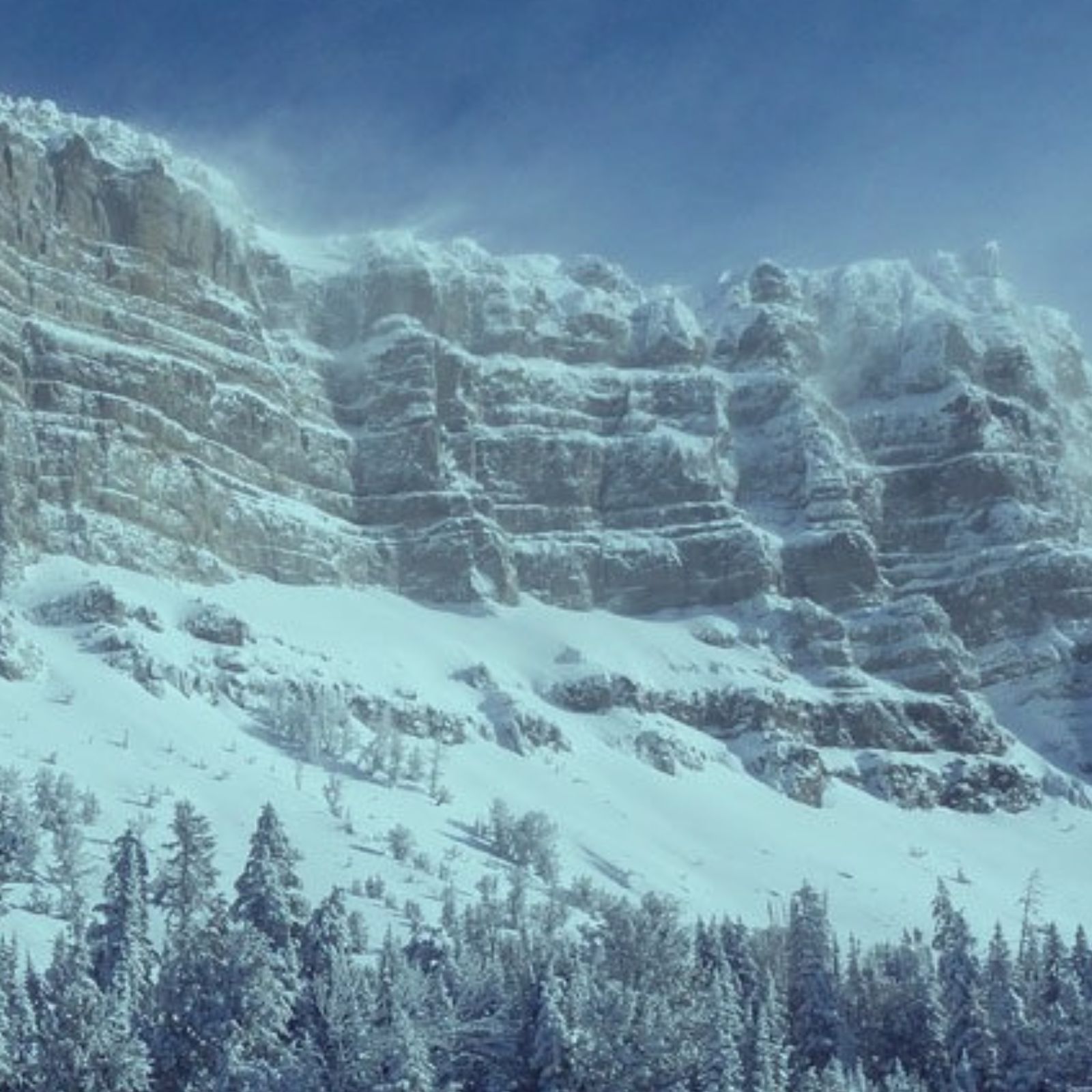
Radio Tower Couloir
Just a little further on Highway 26 towards Dubois, look for parking on the left.
This is the only sane line off the highway side of the 11,000′ Brooks Mountain. I mean, look at the picture, it’s probably the only line you’ll survive without a rope.
Bring the crampons probably. You can work the long way around the backside, but you may prefer to huff it up the couloir.
The entrance to the chute is steep, but it mellows out pretty quickly. You can also chose to follow the ridge line for some less adventurous terrain if you forgot your Mountain Dew.
Enjoy the Togwotee Pass Backcountry Region
Togwotee Pass is an oft-overlooked chunk of Wyoming alpine backcountry. Most of the tourists are headed for the Teton range or Yellowstone. But Togwotee Pass has been ski-traversed for generations. Remnants of the tow rope on Two Ocean Mountain pre-date Jackson Hole itself.
The zone is worth it for a dedicated trek or a stop off. Given optimal conditions, it offers a world-class collection of backcountry routes in impressive proximity. Of course, always check conditions, and keep those backcountry safety and rescue skills honed. And don’t forget to reach out and tell me about your epic trek.